
Thank you for supporting this site ❤️
Make a donation
Make a donation
Gear up for your next adventure:
As an Amazon Associate, this site earns from qualifying purchases at no extra cost to you.
Finhaut topographic map
Click on the map to display elevation.
Thank you for supporting this site ❤️
Make a donation
Make a donation
Gear up for your next adventure:
🧦Merino Wool Hiking Socks - Moisture-wicking socks to prevent blisters during long topographic surveys
As an Amazon Associate, this site earns from qualifying purchases at no extra cost to you.
About this map
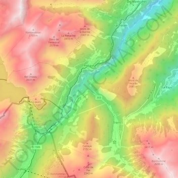
Name: Finhaut topographic map, elevation, terrain.
Location: Finhaut, Saint-Maurice, Wallis, 1925, Switzerland (46.04197 6.87207 46.10142 6.99262)
Average elevation: 1,730 m
Minimum elevation: 656 m
Maximum elevation: 2,817 m
Thank you for supporting this site ❤️
Make a donation
Make a donation
Gear up for your next adventure:
As an Amazon Associate, this site earns from qualifying purchases at no extra cost to you.
Other topographic maps
Click on a map to view its topography, its elevation and its terrain.