
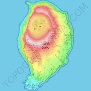
Ilha do Corvo topographic map
Interactive map
Click on the map to display elevation.
About this map
Name: Ilha do Corvo topographic map, elevation, terrain.
Location: Ilha do Corvo, Vila do Corvo, Corvo, Azores, Portugal (39.66923 -31.12851 39.72618 -31.08225)
Average elevation: 148 m
Minimum elevation: -2 m
Maximum elevation: 705 m
The island is located on the North American Plate, west of the Mid-Atlantic Ridge on a sea-mount of approximately 1.5-1.0 million years age. The islands of Corvo and Flores emerged from a submarine mount oriented along a north-northeast to south-southwest line, while Corvo is controlled by faults oriented north to south, parallel to the mid-Atlantic Ridge, and transform faults oriented west to east which crosscut secondary cones on the outer slopes. The island formed from a 5 km diameter central volcano (Monte Gorde) that emerged around 730,000 years ago, whose central cone was approximately 1,000 m (3,300 ft) in altitude. The crater collapsed 430,000 years ago during a Plinian eruption, forming a subsidence caldera (2,000 m (7,000 ft) in diameter and 300 m (1,000 ft) depth), referred to as the Caldeirão. Within the caldera are several cinder and spatter cones (20–30 m (65–100 ft) in height) giving rise to small lakes, peat bogs, and islets (two long and five rounded). The highest point on the island, the Morro dos Homens, crowns the southern rim of the Caldeirão at 718 m (2,356 ft) above sea level.