
Make a donation
Gear up for your next adventure:
As an Amazon Associate, this site earns from qualifying purchases at no extra cost to you.
Mae Rim topographic map
Click on the map to display elevation.
Make a donation
Gear up for your next adventure:
As an Amazon Associate, this site earns from qualifying purchases at no extra cost to you.
About this map
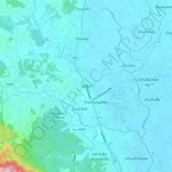
Name: Mae Rim topographic map, elevation, terrain.
Location: Mae Rim, Rim Nuea, Chiang Mai Province, 50180, Thailand (18.87446 98.90527 18.95446 98.98527)
Average elevation: 340 m
Minimum elevation: 309 m
Maximum elevation: 721 m
Make a donation
Gear up for your next adventure:
As an Amazon Associate, this site earns from qualifying purchases at no extra cost to you.
Other topographic maps
Click on a map to view its topography, its elevation and its terrain.
Chiang Mai Province
Thailand > Chiang Mai Province
Chiang Mai Province is about 685 km (426 mi) from Bangkok in the Mae Ping River basin and is on average at 300 m (1,000 ft) elevation. Surrounded by the mountain ranges of the Thai highlands, it covers an area of approximately 20,107 km2 (8,000 sq mi). The mountains of the Daen Lao Range…
Average elevation: 649 m