Geolocate

Stevenage topographic map

Click on the map to display elevation.

About this map
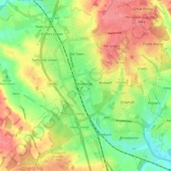
Name: Stevenage topographic map, elevation, terrain.

Location: Stevenage, Hertfordshire, England, United Kingdom (51.86932 -0.23438 51.93243 -0.14680)

Average elevation: 108 m

Minimum elevation: 70 m

Maximum elevation: 147 m

Other topographic maps

Click on a map to view its topography, its elevation and its terrain.
Cheshunt

United Kingdom > England > Hertfordshire

Average elevation: 43 m

Potters Bar

United Kingdom > England > Hertfordshire > Hertsmere

Average elevation: 98 m

Holywell

United Kingdom > England > Hertfordshire > Watford

Average elevation: 68 m

Gear up for your next adventure:

💡Collapsible Camping Lanterns - Illuminate your base camp or tent for map studying at night
🩹Blister Prevention Tape - Apply to friction points before they become painful sores
📡Satellite Messengers - Emergency communication devices
🧴SPF 50+ Bulk Sunscreen - Maximum protection for long-term outdoor exposure
📕Hiking Guide Books - Guides for hiking trails

As an Amazon Associate, this site earns from qualifying purchases at no extra cost to you.