
Cantón Turrialba topographic map
Interactive map
Click on the map to display elevation.
Cantón Turrialba
Turrialba has an area of 1,642.67 km² and a mean elevation of 768 metres.
About this map
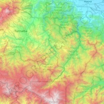
Name: Cantón Turrialba topographic map, elevation, terrain.
Location: Cantón Turrialba, Cartago Province, Costa Rica (9.48431 -83.81933 10.08383 -83.31560)
Average elevation: 1,317 m
Minimum elevation: 0 m
Maximum elevation: 3,740 m
Other topographic maps
Click on a map to view its topography, its elevation and its terrain.