Geolocate

Ratho topographic map

Click on the map to display elevation.

About this map

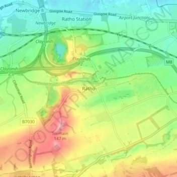
Name: Ratho topographic map, elevation, terrain.

Location: Ratho, City of Edinburgh, Scotland, EH28 8RS, United Kingdom (55.90150 -3.40341 55.94150 -3.36341)

Average elevation: 80 m

Minimum elevation: 32 m

Maximum elevation: 149 m

Other topographic maps

Click on a map to view its topography, its elevation and its terrain.

West End

United Kingdom > Scotland > City of Edinburgh

Average elevation: 59 m

Gear up for your next adventure:

🧥Softshell Jackets - Flexible outdoor jackets
📣High-Decibel Survival Whistles - Signaling tool for rescue that carries much further than a human voice
🎒Tactical Waist Packs - Quick access to your compass, phone, and snacks while walking
🧢Outdoor Sun Hats - Sun protection hats for hiking
🍴Titanium Spork & Cutlery - Indestructible and feather-light eating utensils

As an Amazon Associate, this site earns from qualifying purchases at no extra cost to you.