
Eungai Creek topographic map
Interactive map
Click on the map to display elevation.
About this map
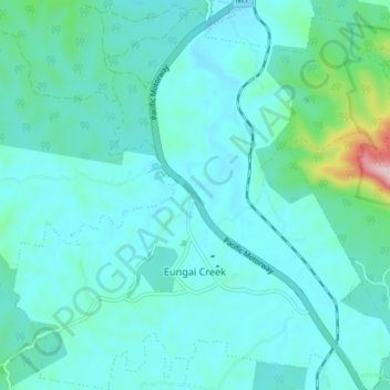
Name: Eungai Creek topographic map, elevation, terrain.
Average elevation: 51 m
Minimum elevation: 2 m
Maximum elevation: 376 m
Other topographic maps
Click on a map to view its topography, its elevation and its terrain.
Browns Crossing
Australia > New South Wales > Eungai Creek > Browns Crossing
Browns Crossing, Eungai Creek, Nambucca Valley Council, New South Wales, 2441, Australia
Average elevation: 50 m