
Mid Suffolk topographic map
Interactive map
Click on the map to display elevation.
About this map
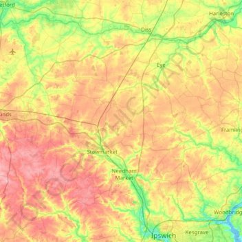
Name: Mid Suffolk topographic map, elevation, terrain.
Location: Mid Suffolk, Suffolk, East of England, England, United Kingdom (52.06514 0.79755 52.40440 1.40948)
Average elevation: 50 m
Minimum elevation: 0 m
Maximum elevation: 107 m
Other topographic maps
Click on a map to view its topography, its elevation and its terrain.
Stradbroke
United Kingdom > England > Mid Suffolk > Stradbroke
Stradbroke, Suffolk, East of England, England, IP21 5HT, United Kingdom
Average elevation: 51 m