
Wychavon topographic map
Interactive map
Click on the map to display elevation.
About this map
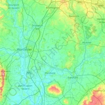
Name: Wychavon topographic map, elevation, terrain.
Location: Wychavon, Worcestershire, England, United Kingdom (51.99941 -2.27605 52.36121 -1.75741)
Average elevation: 68 m
Minimum elevation: 6 m
Maximum elevation: 418 m
Other topographic maps
Click on a map to view its topography, its elevation and its terrain.
South Littleton
United Kingdom > England > Worcestershire > Wychavon
South Littleton, Wychavon, Worcestershire, England, United Kingdom
Average elevation: 38 m
Evesham
United Kingdom > England > Worcestershire > Wychavon
Evesham, Wychavon, Worcestershire, England, United Kingdom
Average elevation: 38 m
Kemerton
United Kingdom > England > Worcestershire > Wychavon
Kemerton, Wychavon, Worcestershire, England, United Kingdom
Average elevation: 85 m
Hill End
United Kingdom > England > Worcestershire > Wychavon
Hill End, Wychavon, Worcestershire, England, WR9 8LJ, United Kingdom
Average elevation: 47 m