
Traveston topographic map
Interactive map
Click on the map to display elevation.
About this map
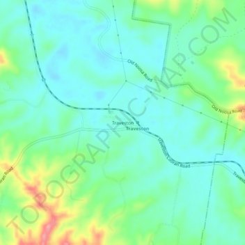
Name: Traveston topographic map, elevation, terrain.
Location: Traveston, Queensland, Australia (-26.33980 152.76022 -26.29980 152.80022)
Average elevation: 89 m
Minimum elevation: 60 m
Maximum elevation: 169 m
Other topographic maps
Click on a map to view its topography, its elevation and its terrain.
Traveston
Australia > Queensland > Traveston
Traveston, Gympie Regional, Queensland, Australia
Average elevation: 111 m