
St. Andrew topographic map
Interactive map
Click on the map to display elevation.
About this map
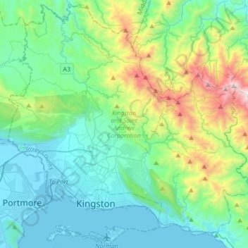
Name: St. Andrew topographic map, elevation, terrain.
Location: St. Andrew, Surrey County, Jamaika (17.92821 -76.89715 18.17103 -76.62675)
Average elevation: 419 m
Minimum elevation: -2 m
Maximum elevation: 1,908 m
Other topographic maps
Click on a map to view its topography, its elevation and its terrain.
Jamaica
Jamaica, Spanish Town, Saint Catherine, Middlesex County, Jamaika
Average elevation: 65 m