
Lewiston topographic map
Interactive map
Click on the map to display elevation.
About this map
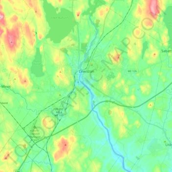
Name: Lewiston topographic map, elevation, terrain.
Location: Lewiston, Androscoggin County, Maine, 04240, United States (44.00535 -70.22426 44.16752 -70.11525)
Average elevation: 86 m
Minimum elevation: 30 m
Maximum elevation: 212 m
Other topographic maps
Click on a map to view its topography, its elevation and its terrain.
Bird Poop Island
United States > Maine > Androscoggin County > Auburn
Bird Poop Island, Auburn, Androscoggin County, Maine, 04210, United States
Average elevation: 87 m
Mount Giles
United States > Maine > Androscoggin County > Auburn
Mount Giles, Auburn, Androscoggin County, Maine, United States
Average elevation: 87 m