
Coolum topographic map
Interactive map
Click on the map to display elevation.
About this map
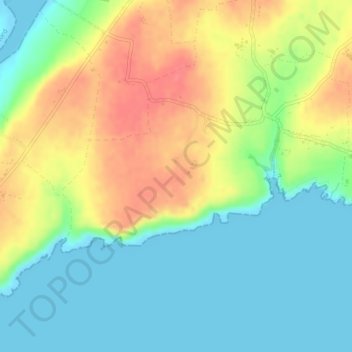
Name: Coolum topographic map, elevation, terrain.
Average elevation: 26 m
Minimum elevation: -1 m
Maximum elevation: 63 m
Other topographic maps
Click on a map to view its topography, its elevation and its terrain.
Took
Took, Modelligo, The Municipal District of Dungarvan — Lismore, County Waterford, Munster, Ireland
Average elevation: 169 m
Ballymacarbry
Ballymacarbry, The Municipal District of Comeragh, County Waterford, Munster, Ireland
Average elevation: 145 m
Waterford
Waterford, County Waterford, Munster, Ireland
Average elevation: 33 m
Dromana
Dromana, The Municipal District of Dungarvan — Lismore, County Waterford, Munster, Ireland
Average elevation: 34 m