
Winthrop topographic map
Interactive map
Click on the map to display elevation.
About this map
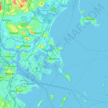
Name: Winthrop topographic map, elevation, terrain.
Average elevation: 5 m
Minimum elevation: -3 m
Maximum elevation: 71 m
Other topographic maps
Click on a map to view its topography, its elevation and its terrain.
Flagstaff Hill
United States > Massachusetts > Suffolk County > Boston
Flagstaff Hill, Boston, Suffolk County, Massachusetts, 02108, United States
Average elevation: 11 m
Burden Park
United States > Massachusetts > Suffolk County > Boston
Burden Park, Barry's Corner, Allston, Boston, Suffolk County, Massachusetts, United States
Average elevation: 8 m
Boston
United States > Massachusetts > Suffolk County
Boston, Suffolk County, Massachusetts, United States
Average elevation: 25 m