
Marikina topographic map
Interactive map
Click on the map to display elevation.
About this map
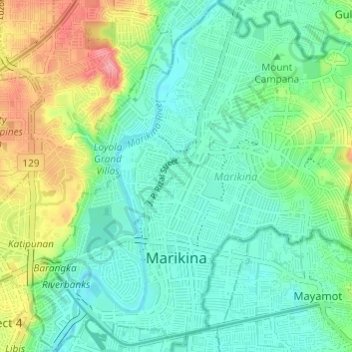
Name: Marikina topographic map, elevation, terrain.
Location: Marikina, NCR, Second District, Metro Manila, Philippines (14.61774 121.07437 14.67559 121.13496)
Average elevation: 30 m
Minimum elevation: 2 m
Maximum elevation: 96 m
Other topographic maps
Click on a map to view its topography, its elevation and its terrain.
flood prone
flood prone, Industrial Valley, Marikina, Eastern Manila District, Metro Manila, 1802, Philippines
Average elevation: 27 m