
Austin County topographic map
Interactive map
Click on the map to display elevation.
About this map
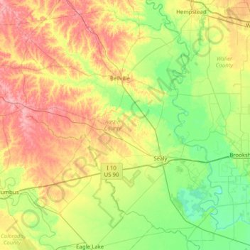
Name: Austin County topographic map, elevation, terrain.
Location: Austin County, Texas, United States (29.60185 -96.62220 30.09722 -96.00477)
Average elevation: 67 m
Minimum elevation: 22 m
Maximum elevation: 140 m
Other topographic maps
Click on a map to view its topography, its elevation and its terrain.
New Ulm
United States > Texas > Austin County
New Ulm, Austin County, Texas, 78950, United States
Average elevation: 118 m
Bellville
United States > Texas > Austin County
Bellville, Austin County, Texas, United States
Average elevation: 72 m
Sealy
United States > Texas > Austin County
Sealy, Austin County, Texas, 77474, United States
Average elevation: 55 m