
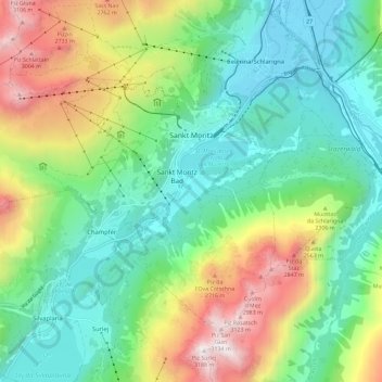
Sankt Moritz topographic map
Interactive map
Click on the map to display elevation.
About this map
Name: Sankt Moritz topographic map, elevation, terrain.
Location: Sankt Moritz, Maloja, Grisons, 7500, Switzerland (46.45772 9.74936 46.51460 9.86454)
Average elevation: 2,174 m
Minimum elevation: 1,708 m
Maximum elevation: 3,157 m
St. Moritz (/ˌsæn məˈrɪts/ SAN mə-RITS, US also /ˌseɪnt -/ SAYNT -, UK also /sənt ˈmɒrɪts/ sənt MORR-its; German, in full: Sankt Moritz [zaŋkt moˈrɪts, ˈmoːrɪts] locally [saŋkt]; Romansh: San Murezzan [sam muˈʁetsən] ; Italian: San Maurizio; French: Saint-Moritz) is a high Alpine resort town in the Engadine in Switzerland, at an elevation of about 1,800 metres (5,910 ft) above sea level. It is Upper Engadine's major town and a municipality in the district of Maloja in the Swiss canton of Graubünden.
Other topographic maps
Click on a map to view its topography, its elevation and its terrain.
Madulain
Switzerland > Grisons > Maloja
Madulain, Maloja, Grisons, 7523, Switzerland
Average elevation: 2,330 m