
Juliette topographic map
Interactive map
Click on the map to display elevation.
About this map
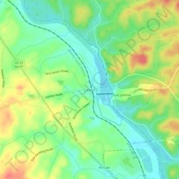
Name: Juliette topographic map, elevation, terrain.
Location: Juliette, Monroe County, Georgia, United States (33.08699 -83.81912 33.12699 -83.77912)
Average elevation: 130 m
Minimum elevation: 105 m
Maximum elevation: 163 m
Other topographic maps
Click on a map to view its topography, its elevation and its terrain.
High Falls Lake
United States > Georgia > Monroe County > High Falls
High Falls Lake, High Falls, Monroe County, Georgia, United States
Average elevation: 191 m
Bolingbroke
United States > Georgia > Monroe County
Bolingbroke, Monroe County, Georgia, 31004, United States
Average elevation: 168 m
High Falls State Park
United States > Georgia > Monroe County > High Falls
High Falls State Park, High Falls, Monroe County, Georgia, United States
Average elevation: 185 m
Moran
United States > Georgia > Monroe County > Moran
Moran, Monroe County, Georgia, United States
Average elevation: 145 m
Forsyth
United States > Georgia > Monroe County
Forsyth, Monroe County, Georgia, 31029, United States
Average elevation: 194 m