
Border Southern Highlands - Western Highlands topographic map
Interactive map
Click on the map to display elevation.
About this map
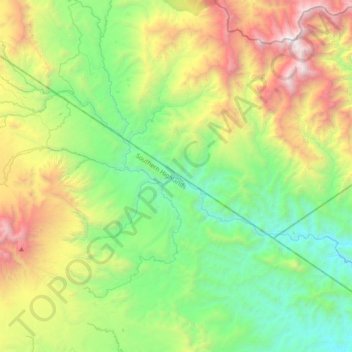
Name: Border Southern Highlands - Western Highlands topographic map, elevation, terrain.
Average elevation: 1,625 m
Minimum elevation: 594 m
Maximum elevation: 3,818 m
Other topographic maps
Click on a map to view its topography, its elevation and its terrain.
Mount Hagen
Papua New Guinea > Western Highlands > Mount Hagen District
Mount Hagen, Mount Hagen District, Western Highlands, Highlands Region, 281, Papua New Guinea
Average elevation: 1,904 m
Kaupena
Papua New Guinea > Western Highlands > Kaupena
Kaupena, Mount Hagen District, Western Highlands, Highlands Region, Papua New Guinea
Average elevation: 1,331 m