
Orange River topographic map
Interactive map
Click on the map to display elevation.
Orange River
During the temperate months of March and April, given good rains and the sluices of the dams being open, a canoeist (or rafter) can easily travel 30 km per day. The lower reaches of the river are most popular, because of the spectacular topography. Commercial tours are available, and these expeditions depart from the border town of Vioolsdrif.
About this map
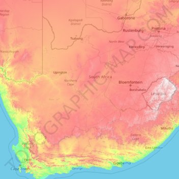
Name: Orange River topographic map, elevation, terrain.
Location: Orange River, 8850, South Africa (-30.69413 16.44945 -28.03360 29.07203)
Average elevation: 967 m
Minimum elevation: 0 m
Maximum elevation: 3,373 m
Other topographic maps
Click on a map to view its topography, its elevation and its terrain.
Carnarvon
South Africa > Northern Cape > Pixley ka Seme District Municipality > Kareeberg Local Municipality
Average elevation: 1,272 m
Upington
South Africa > Northern Cape > ZF Mgcawu District Municipality
The elevation of Upington is 2,742 feet (835 metres). It is the closest large centre to the Augrabies Falls (arguably the greatest of South African waterfalls) and the Kgalagadi Transfrontier Park. The landscape is very arid but the soil is fertile and crops such as fruit are grown in irrigated fields. The…
Average elevation: 849 m
Hopetown
South Africa > Northern Cape > Pixley ka Seme District Municipality > Thembelihle Local Municipality
Average elevation: 1,101 m
Kimberley
South Africa > Northern Cape > Frances Baard District Municipality > Kimberley
Kimberley is set in a relatively flat landscape with no prominent topographic features within the urban limits. The only "hills" are debris dumps generated by more than a century of diamond mining. From the 1990s these were being recycled and poured back into De Beers Mine (by 2010 it was filled to within a…
Average elevation: 1,191 m
Springbok
South Africa > Northern Cape > Namakwa District Municipality > Nama Khoi Local Municipality
Average elevation: 927 m
Kimberley
South Africa > Northern Cape > Frances Baard District Municipality
Kimberley is set in a relatively flat landscape with no prominent topographic features within the urban limits. The only "hills" are debris dumps generated by more than a century of diamond mining. From the 1990s these were being recycled and poured back into De Beers Mine (by 2010 it was filled to within a…
Average elevation: 1,203 m