
Charlemont topographic map
Interactive map
Click on the map to display elevation.
About this map
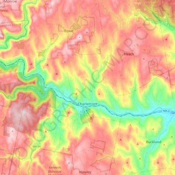
Name: Charlemont topographic map, elevation, terrain.
Location: Charlemont, Franklin County, Massachusetts, United States (42.61118 -72.95555 42.67397 -72.73512)
Average elevation: 407 m
Minimum elevation: 136 m
Maximum elevation: 636 m
Other topographic maps
Click on a map to view its topography, its elevation and its terrain.
Greenfield
United States > Massachusetts > Franklin County > Greenfield
Greenfield, Franklin County, Massachusetts, 01301, United States
Average elevation: 114 m