
Kembla Grange topographic map
Interactive map
Click on the map to display elevation.
About this map
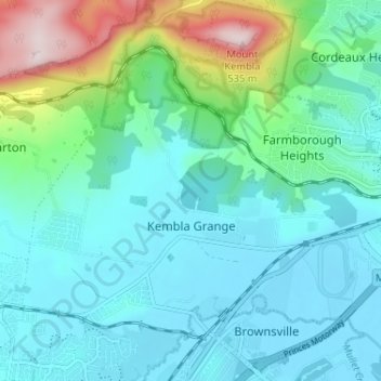
Name: Kembla Grange topographic map, elevation, terrain.
Average elevation: 105 m
Minimum elevation: -1 m
Maximum elevation: 527 m
New South Wales trails, hiking, mountain biking, running and outdoor activities
Other topographic maps
Click on a map to view its topography, its elevation and its terrain.
Flat Rock Junction
Australia > New South Wales > Wollongong City Council > Flat Rock Junction
Average elevation: 334 m
Mount Kembla
Australia > New South Wales > Wollongong City Council
The summit of Mount Kembla has an elevation of 534 metres (1,752 ft) above sea level.
Average elevation: 227 m