
Wewak District topographic map
Interactive map
Click on the map to display elevation.
About this map
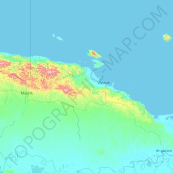
Name: Wewak District topographic map, elevation, terrain.
Location: Wewak District, East Sepik, Momase Region, Papua New Guinea (-4.28333 142.80000 -2.88333 144.20000)
Average elevation: 63 m
Minimum elevation: -1 m
Maximum elevation: 1,104 m
Other topographic maps
Click on a map to view its topography, its elevation and its terrain.
Frieda River
Frieda River, East Sepik, Momase Region, Papua New Guinea
Average elevation: 177 m
Maprik
Papua New Guinea > East Sepik > Maprik
Maprik, East Sepik, Momase Region, Papua New Guinea
Average elevation: 215 m
Sepik River
Sepik River, Ambunti District, East Sepik, Momase Region, Papua New Guinea
Average elevation: 648 m
Angoram
Angoram, East Sepik, Momase Region, Papua New Guinea
Average elevation: 11 m
Kairiru Island
Kairiru Island, Wewak District, East Sepik, Momase Region, Papua New Guinea
Average elevation: 65 m
Blup Blup
Blup Blup, Wewak District, East Sepik, Momase Region, Papua New Guinea
Average elevation: 78 m