
Dili topographic map
Interactive map
Click on the map to display elevation.
Dili
The main city lies within an area of flat lowlands of less than 100m altitude and a slope under 15 degrees. This distance between the sea and the mountains reaches a maximum width of only 4 kilometres (2.5 mi), and the surrounding mountains slope near the city at angles of 20 degrees or higher. The old quarter of the city lies within what is now the eastern half. This area is the most densely built up, with little available land. The western side is the location of the airport and most recent urban growth. On either side of this main city are mountain ridges extending from the southern range to the coast, leading to urban development spilling over onto areas of flat land on the other sides of these spurs. Tibar lies on the opposite site of the western range, while Hera lies on the opposite side of the eastern range. Another spur encloses Hera on its east.
About this map
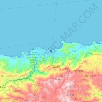
Name: Dili topographic map, elevation, terrain.
Location: Dili, Vera Cruz, Dili, East Timor (-8.71368 125.41841 -8.39368 125.73841)
Average elevation: 337 m
Minimum elevation: -1 m
Maximum elevation: 1,460 m