
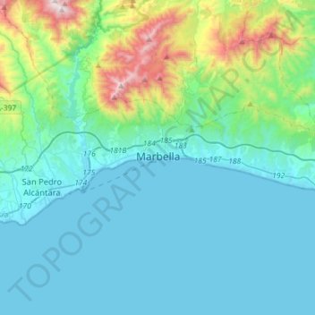
Marbella topographic map
Interactive map
Click on the map to display elevation.
About this map
Name: Marbella topographic map, elevation, terrain.
Location: Marbella, Malaga, Andalusia, Spain (36.46001 -5.01467 36.55497 -4.73057)
Average elevation: 216 m
Minimum elevation: -1 m
Maximum elevation: 1,319 m
There are five geomorphological units: the Sierra Blanca, the Sierra Blanca piedmont (foothills), the lower hill country, the plains and the coastal dunes. The Sierra Blanca is most centrally located in the province, looming over the old village. This mountain range has three peaks: La Concha, located further west at 1,215 m above sea level, Juanar Cross, located eastward (within the municipality of Ojen) at 1,178 m above sea level, and the highest, Mount Lastonar, located between the two at 1,270 metres. Marbella's topography is characterised by extensive coastal plains formed from eroded mountains. After the plain lies an area of higher elevations of between 100 and 400 m, occupied by low hills, behind which rise the foothills and steeper slopes of the mountains. The coast is generally low and has sandy beaches that are more extensive further east, between the fishing port and the Cabopino. Despite the intense urbanisation of the coast, it still retains a natural area of dunes, the Artola Dunes (Dunas de Artola), at the eastern end of town.