
Benton Harbor topographic map
Interactive map
Click on the map to display elevation.
About this map
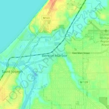
Name: Benton Harbor topographic map, elevation, terrain.
Location: Benton Harbor, Berrien County, Michigan, United States (42.09256 -86.47734 42.14175 -86.41093)
Average elevation: 186 m
Minimum elevation: 172 m
Maximum elevation: 216 m
Other topographic maps
Click on a map to view its topography, its elevation and its terrain.
Chikaming Township
United States > Michigan > Berrien County
Chikaming Township, Berrien County, Michigan, United States
Average elevation: 193 m
New Buffalo Township
United States > Michigan > Berrien County > New Buffalo Township
New Buffalo Township, Berrien County, Michigan, United States
Average elevation: 187 m