
Avranches topographic map
Interactive map
Click on the map to display elevation.
About this map
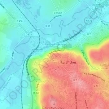
Name: Avranches topographic map, elevation, terrain.
Average elevation: 42 m
Minimum elevation: 3 m
Maximum elevation: 112 m
Le toponyme primitif Ingena contient un élément gen qui semble se retrouver dans Genêts (jadis Genecium ou Genitium) et Argennes (Jadis Aregenna à Saint-Quentin-sur-le-Homme), lieux des environs. Par ailleurs, cet élément se reconnaît également dans Aregenua, ancien nom de Vieux-la-Romaine (Calvados) et à l'étranger dans Genua (Genova, Genève) et Gênes (Genua). Cette racine gen- est considérée comme celtique et on reconstruit sa forme allongée *genu- « bouche » cf. pluriel breton genou, gallois genau. D'où son utilisation topographique au sens d'« embouchure ».
Other topographic maps
Click on a map to view its topography, its elevation and its terrain.
Saint-Martin-des-Champs
France > Normandie > Manche > Avranches
Saint-Martin-des-Champs, Avranches, Manche, Normandie, France métropolitaine, 50300, France
Average elevation: 66 m