
Vigevano topographic map
Interactive map
Click on the map to display elevation.
About this map
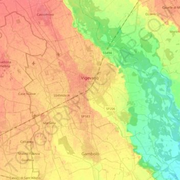
Name: Vigevano topographic map, elevation, terrain.
Location: Vigevano, Pavia, Lombardy, 27029, Italy (45.26065 8.78723 45.35485 8.98260)
Average elevation: 101 m
Minimum elevation: 69 m
Maximum elevation: 124 m
Other topographic maps
Click on a map to view its topography, its elevation and its terrain.