
Cesar topographic map
Interactive map
Click on the map to display elevation.
About this map
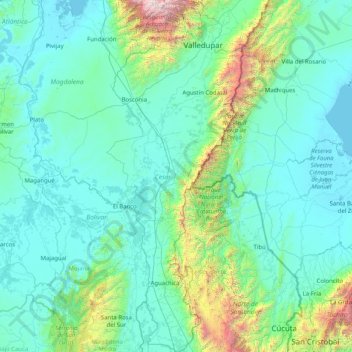
Name: Cesar topographic map, elevation, terrain.
Location: Cesar, RAP Caribe, Colombia (7.67639 -74.13981 10.86762 -72.88583)
Average elevation: 413 m
Minimum elevation: -2 m
Maximum elevation: 5,467 m
Climate in the Department of Cesar presents variations in climate depending on altitude, as well as rainfall precipitations. Mountain climate in the Sierra Nevada de Santa Marta and the Serranía del Perijá become cooler with higher altitude, reaching freezing low temperatures on the snowy peaks. Lowlands average a temperature throughout the year of 28 °C or 82.4 °F. These lower lands present a hot and drier climate, with annual precipitation less than 1,300 millimetres or 51 inches a year. The mountainous regions are characterized by low temperatures with snow on high altitude peaks and precipitation reaching more than 2,000 millimetres or 79 inches a year.
Other topographic maps
Click on a map to view its topography, its elevation and its terrain.
Bogota, Capital District
Bogota, Capital District, RAP (Especial) Central, Colombia
Average elevation: 2,183 m
Perimetro Urbano Pereira
Perimetro Urbano Pereira, Pereira, Risaralda, RAP Eje Cafetero, Colombia
Average elevation: 1,486 m
Palmira
Palmira, Sur, Valle del Cauca, RAP Pacífico, Colombia
Average elevation: 1,600 m
Cali
Colombia > Valle del Cauca > Cali
Cali, Sur, Valle del Cauca, RAP Pacífico, Colombia
Average elevation: 1,140 m
Comuna 4
Colombia > Valle del Cauca > Perímetro Urbano Santiago de Cali
Comuna 4, Perímetro Urbano Santiago de Cali, Cali, Sur, Valle del Cauca, Colombia
Average elevation: 964 m
Perímetro Urbano Barranquilla
Colombia > Atlántico > Barranquilla
Perímetro Urbano Barranquilla, Barranquilla, Atlántico, Colombia
Average elevation: 29 m
Olaya Herrera (Bocas de Satinga)
Colombia > Nariño > Olaya Herrera (Bocas de Satinga)
Olaya Herrera (Bocas de Satinga), Sanquianga, Nariño, Colombia
Average elevation: 13 m
Villa de Leyva
Colombia > Boyacá > Villa de Leyva
Villa de Leyva, Ricaurte, Boyacá, Colombia
Average elevation: 2,416 m
Cove Road
Colombia > Archipiélago de San Andrés, Providencia y Santa Catalina > San Andrés > Cove Road
Cove Road, San Andrés, Archipiélago de San Andrés, Providencia y Santa Catalina, Colombia
Average elevation: 12 m
Bucaramanga
Colombia > Santander > Bucaramanga
Bucaramanga, Santander, Colombia
Average elevation: 1,196 m
Bogota Capital District
Colombia > Bogota Capital District
Bogota Capital District, 11001, Colombia
Average elevation: 2,183 m
Kennedy
Colombia > Bogota Capital District > Kennedy
Kennedy, Bogota, Bogota Capital District, Colombia
Average elevation: 2,550 m
San Francisco
San Francisco, Recetor, Casanare, Colombia
Average elevation: 1,463 m
Usme
Colombia > Bogota Capital District > Usme
Usme, Bogota Capital District, Colombia
Average elevation: 3,111 m