
Étang topographic map
Interactive map
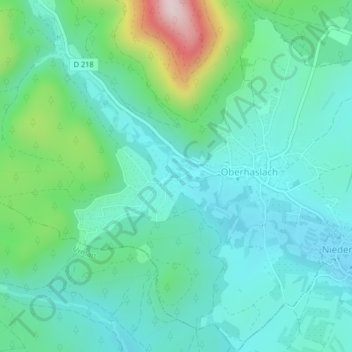
Click on the map to display elevation.
About this map
Name: Étang topographic map, elevation, terrain.
Average elevation: 336 m
Minimum elevation: 254 m
Maximum elevation: 620 m
Other topographic maps
Click on a map to view its topography, its elevation and its terrain.
Cascade du Nideck
France > Grand Est > Oberhaslach
Cascade du Nideck, Oberhaslach, Molsheim, Bas-Rhin, Grand Est, France métropolitaine, 67280, France
Average elevation: 582 m
Château du Petit-Ringelstein (ou Petit-Ringelsberg)
France > Grand Est > Oberhaslach
Château du Petit-Ringelstein (ou Petit-Ringelsberg), Kammweg, Maison Forestière du Nideck, Oberhaslach, Molsheim, Bas-Rhin, Grand Est, France métropolitaine, 67280, France
Average elevation: 538 m