
Henry Mountains topographic map
Interactive map
Click on the map to display elevation.
About this map
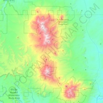
Name: Henry Mountains topographic map, elevation, terrain.
Location: Henry Mountains, Garfield County, Utah, USA (37.84938 -110.89874 38.20150 -110.60211)
Average elevation: 1,936 m
Minimum elevation: 1,346 m
Maximum elevation: 3,502 m
Other topographic maps
Click on a map to view its topography, its elevation and its terrain.
Logan River
Logan River, Logan, Cache County, Utah, 84321, USA
Average elevation: 1,430 m
La Sal Mountains Viewpoint
La Sal Mountains Viewpoint, Arches Entrance Road, Grand County, Utah, 84532-2134, USA
Average elevation: 1,347 m
Timpanogos Glacier
USA > Utah > Aspen Grove
Timpanogos Glacier, Mount Timpanogos Trail #052, Aspen Grove, Utah County, Utah, USA
Average elevation: 3,148 m
Kanab Creek
Kanab Creek, Kanab, Kane County, Utah, 86074, USA
Average elevation: 1,500 m
Canyonlands National Park - Maze District
Canyonlands National Park - Maze District, White Rim Road, San Juan County, Utah, USA
Average elevation: 1,546 m
Castle Cliff
USA > Utah > St. George
Castle Cliff, Old US Highway 91, St. George, Washington County, Utah, USA
Average elevation: 1,204 m