
Central Tigray topographic map
Interactive map
Click on the map to display elevation.
About this map
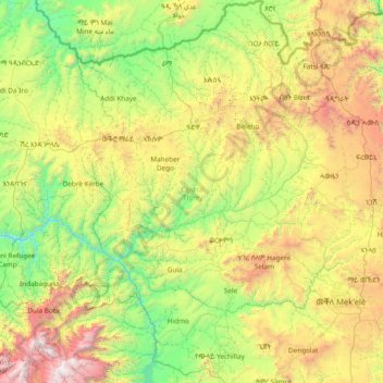
Name: Central Tigray topographic map, elevation, terrain.
Location: Central Tigray, Tigray, Ethiopia (13.17064 38.43027 14.65325 39.42014)
Average elevation: 1,902 m
Minimum elevation: 876 m
Maximum elevation: 4,482 m
Other topographic maps
Click on a map to view its topography, its elevation and its terrain.
Adi Almeban
Adi Almeban, Maychew, Southern Tigray, Tigray, Ethiopia
Average elevation: 2,692 m
Adi Bidera (1)
Ethiopia > Tigray > Adi Bidera (1)
Adi Bidera (1), Southern Tigray, Tigray, Ethiopia
Average elevation: 1,645 m
Roof Water Catchment
Ethiopia > Tigray > Maheber Dego
Roof Water Catchment, Maheber Dego, Central Tigray, Tigray, Ethiopia
Average elevation: 2,079 m