
Baffin Island topographic map
Interactive map
Click on the map to display elevation.
About this map
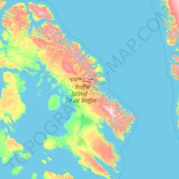
Name: Baffin Island topographic map, elevation, terrain.
Location: Baffin Island, Canada (61.86201 -90.11200 73.86118 -61.26000)
Average elevation: 132 m
Minimum elevation: -2 m
Maximum elevation: 2,002 m
The Baffin Mountains run along the northeastern coast of the island and are a part of the Arctic Cordillera. The highest peak is Mount Odin, with an elevation of at least 2,143 m (7,031 ft), although some sources say 2,147 m (7,044 ft). Another peak of note is Mount Asgard, located in Auyuittuq National Park, with an elevation of 2,011 m (6,598 ft). Mount Thor, with an elevation of 1,675 m (5,495 ft), is said to have the greatest purely vertical drop (a sheer cliff face) of any mountain on Earth, at 1,250 m (4,100 ft). Mount Sharat, with an elevation of 422 m (1,385 ft) and a prominence of 67 m (220 ft) is located on Baffin Island. The mountain is named after geologist Sharat Kumar Roy, the chief geology curator in the Field Museum of Natural History, Chicago. Roy, a native of India, studied in India, London, and earned his Ph.D. at the University of Chicago. Shortly after he started at the Field Museum he joined the 1927-1928 Rawson-Macmillan Expedition to Baffin Island and Labrador. This 15-month expedition began in June 1927.
Other topographic maps
Click on a map to view its topography, its elevation and its terrain.
Springton
Canada > Prince Edward Island > Queens County
Springton, Queens County, Prince Edward Island, Canada
Average elevation: 104 m
Goulbourne
Canada > Manitoba > Division No. 18 > Municipality of West Interlake
Goulbourne, Municipality of West Interlake, Division No. 18, Manitoba, Canada
Average elevation: 251 m
Delta
Canada > British Columbia > Metro Vancouver Regional District
Delta, Metro Vancouver Regional District, British Columbia, Canada
Average elevation: 13 m
Stanley Park
Canada > British Columbia > Metro Vancouver Regional District > Vancouver
Stanley Park, West End, Vancouver, Metro Vancouver Regional District, British Columbia, V6G, Canada
Average elevation: 14 m
Lake Ainslie
Canada > Nova Scotia > Municipality of the County of Inverness > MacCormicks Corner
Lake Ainslie, MacCormicks Corner, Municipality of the County of Inverness, Inverness County, Nova Scotia, Canada
Average elevation: 130 m
Bears Back Shoal
Canada > Ontario > Manitoulin District > Northeastern Manitoulin and the Islands
Bears Back Shoal, Northeastern Manitoulin and the Islands, Manitoulin District, Northeastern Ontario, Ontario, Canada
Average elevation: 176 m
Dalhousie Road
Canada > Nova Scotia > Municipality of the County of Kings
Dalhousie Road, East Dalhousie, Municipality of the County of Kings, Kings County, Nova Scotia, B0R 1H0, Canada
Average elevation: 207 m
Glen Williams
Canada > Ontario > Halton Region
Glen Williams, Halton Hills, Halton Region, Golden Horseshoe, Ontario, L7G 3S8, Canada
Average elevation: 262 m
Barons
Canada > Alberta > Division No. 2
Barons, Division No. 2, Alberta, Canada
Average elevation: 965 m
Middleville
Canada > Ontario > Lanark County > Lanark Highlands
Middleville, Lanark Highlands, Lanark County, Eastern Ontario, Ontario, Canada
Average elevation: 183 m
Alliston
Canada > Prince Edward Island > Kings County
Alliston, Kings County, Prince Edward Island, Canada
Average elevation: 60 m
Alliston
Canada > Ontario > Simcoe County
Alliston, New Tecumseth, Simcoe County, Central Ontario, Ontario, L9R 1A0, Canada
Average elevation: 233 m
MacArther Island
Canada > British Columbia > Regional District of Fraser-Fort George > Area G (Crooked River/Parsnip)
MacArther Island, Area G (Crooked River/Parsnip), Regional District of Fraser-Fort George, British Columbia, Canada
Average elevation: 713 m
Mount Barrington
Canada > British Columbia > Regional District of Kitimat-Stikine > Area D (Iskut/Big Raven)
Mount Barrington, Area D (Iskut/Big Raven), Regional District of Kitimat-Stikine, British Columbia, Canada
Average elevation: 1,437 m
Newcastle
Canada > Ontario > Durham Region > Clarington
Newcastle, Clarington, Durham Region, Golden Horseshoe, Ontario, L1B 1L2, Canada
Average elevation: 109 m
Port Nelson
Canada > Manitoba > Division No. 23 > Unorganized Division No. 23
Port Nelson, Unorganized Division No. 23, Division No. 23, Manitoba, Canada
Average elevation: 9 m
Drummond
Canada > New Brunswick > Drummond Parish
Drummond, Drummond Parish, Victoria County, New Brunswick, E3Y 2P6, Canada
Average elevation: 210 m
Parc régional du Poisson-Blanc
Canada > Quebec > Antoine-Labelle > Notre-Dame-du-Laus
Parc régional du Poisson-Blanc, Notre-Dame-du-Laus, Antoine-Labelle, Laurentides, Quebec, Canada
Average elevation: 238 m
Mount Baldy
Canada > British Columbia > qathet Regional District > Area A (Malaspina/Toba)
Mount Baldy, Area A (Malaspina/Toba), qathet Regional District, British Columbia, Canada
Average elevation: 1,246 m
Blackville
Canada > New Brunswick > Blackville Parish
Blackville, Blackville Parish, Northumberland County, New Brunswick, Canada
Average elevation: 52 m
Carleton Place
Canada > Ontario > Lanark County
Carleton Place, Lanark County, Eastern Ontario, Ontario, Canada
Average elevation: 137 m
Eastport
Canada > Newfoundland and Labrador
Eastport, Newfoundland, Newfoundland and Labrador, A0G 1Z0, Canada
Average elevation: 22 m
Canton Island
Canada > Newfoundland and Labrador
Canton Island, Labrador, Newfoundland and Labrador, Canada
Average elevation: 4 m
Swan Islands
Canada > Newfoundland and Labrador
Swan Islands, Newfoundland, Newfoundland and Labrador, Canada
Average elevation: 22 m
Mount Allen
Canada > British Columbia > Regional District of East Kootenay > Area G (Forster Creek/Mount Assiniboine)
Mount Allen, Area G (Forster Creek/Mount Assiniboine), Regional District of East Kootenay, British Columbia, Canada
Average elevation: 2,673 m
Elmsdale
Canada > Nova Scotia > Hants County
Elmsdale, East Hants District Municipality, Hants County, Nova Scotia, Canada
Average elevation: 24 m
Ferme-Neuve
Canada > Quebec > Antoine-Labelle
Ferme-Neuve, Antoine-Labelle, Laurentides, Quebec, Canada
Average elevation: 306 m
Goulburn Islands
Goulburn Islands, Kitikmeot Region, Nunavut, Canada
Average elevation: 20 m
Kingston
Canada > Nova Scotia > Municipality of the County of Kings
Kingston, Municipality of the County of Kings, Kings County, Nova Scotia, B0P 1R0, Canada
Average elevation: 30 m
Frenchman's Head
Canada > Newfoundland and Labrador > Frenchman's Cove
Frenchman's Head, Frenchman's Cove, Newfoundland, Newfoundland and Labrador, A0E 1T0, Canada
Average elevation: 0 m
Mont-Saint-Hilaire
Canada > Quebec > La Vallée-du-Richelieu
Mont-Saint-Hilaire, La Vallée-du-Richelieu, Montérégie, Quebec, Canada
Average elevation: 41 m
Bigger Lake
Canada > Ontario > Rainy River District > Atikokan
Bigger Lake, Atikokan, Rainy River District, Northwestern Ontario, Ontario, Canada
Average elevation: 410 m
Come By Chance
Canada > Newfoundland and Labrador
Come By Chance, Newfoundland, Newfoundland and Labrador, Canada
Average elevation: 58 m
King Island
Canada > British Columbia > Central Coast Regional District
King Island, Central Coast Regional District, British Columbia, Canada
Average elevation: 330 m
Greenfield
Canada > Nova Scotia > Queens County
Greenfield, Region of Queens Municipality, Queens County, Nova Scotia, B0T 1E0, Canada
Average elevation: 85 m
Blacksmith
Canada > Newfoundland and Labrador > Fermeuse
Blacksmith, Fermeuse, Newfoundland, Newfoundland and Labrador, Canada
Average elevation: 39 m
Champlain
Canada > Quebec > Les Chenaux
Champlain, Les Chenaux, Mauricie, Quebec, G0X 1C0, Canada
Average elevation: 17 m
Sechelt
Canada > British Columbia > Sunshine Coast Regional District
Sechelt, Sunshine Coast Regional District, British Columbia, Canada
Average elevation: 196 m
Elliston
Canada > Newfoundland and Labrador
Elliston, Newfoundland, Newfoundland and Labrador, A0C 1N0, Canada
Average elevation: 37 m
Fairlight
Canada > Saskatchewan > Division No. 1
Fairlight, Division No. 1, Saskatchewan, Canada
Average elevation: 591 m