
Churchill County topographic map
Interactive map
Click on the map to display elevation.
About this map
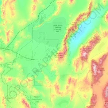
Name: Churchill County topographic map, elevation, terrain.
Location: Churchill County, Nevada, United States (39.07364 -119.22614 40.00304 -117.46018)
Average elevation: 1,476 m
Minimum elevation: 1,029 m
Maximum elevation: 3,027 m
The terrain of Churchill County consists of rugged mountainous ridges, dotted with lakes and ponds. The county's east and west sides are higher than the intermediate valley; its highest point around the county periphery is a ridge on the lower east boundary line, at 9,380' (2859m) ASL. The county has an area of 5,024 square miles (13,010 km2), of which 4,930 square miles (12,800 km2) is land and 94 square miles (240 km2) (1.9%) is water. The county's highest point is Desatoya Peak at 9,977' (3041m), while the most topographically prominent peak is Mount Augusta, at 9,970' (3039m) ASL.
Other topographic maps
Click on a map to view its topography, its elevation and its terrain.
Moapa Valley
United States > Nevada > Clark County
Moapa Valley, Clark County, Nevada, 89021, United States
Average elevation: 520 m
Spring Valley
United States > Nevada > Clark County
Spring Valley, Clark County, Nevada, United States
Average elevation: 736 m
Lake Mead
United States > Nevada > Clark County
Lake Mead, Clark County, Nevada, United States
Average elevation: 684 m
New Washoe City
United States > Nevada > Washoe County
New Washoe City, Washoe County, Nevada, United States
Average elevation: 1,589 m
Mount Baldy
United States > Nevada > Humboldt County
Mount Baldy, Humboldt County, Nevada, United States
Average elevation: 1,641 m
Rachel
United States > Nevada > Lincoln County
Rachel, Lincoln County, Nevada, United States
Average elevation: 1,476 m
Las Vegas
United States > Nevada > Clark County
Las Vegas, Clark County, Nevada, United States
Average elevation: 756 m
Sparks
United States > Nevada > Washoe County > Sparks > Sparks
Sparks, Washoe County, Nevada, 89431-5025, United States
Average elevation: 1,636 m
Sparks
United States > Nevada > Washoe County > Sparks
Sparks, Washoe County, Nevada, United States
Average elevation: 1,438 m
Lake Las Vegas
United States > Nevada > Henderson > Lake Las Vegas
Lake Las Vegas, Henderson, Clark County, Nevada, United States
Average elevation: 455 m
Mount Observation
Mount Observation, Washoe County, Nevada, United States
Average elevation: 1,580 m
Mount Charleston
United States > Nevada > Clark County
Mount Charleston, Clark County, Nevada, United States
Average elevation: 2,560 m
Spring Creek
United States > Nevada > Elko County
Spring Creek, Elko County, Nevada, United States
Average elevation: 1,721 m
Reno
United States > Nevada > Washoe County
Reno, Washoe County, Nevada, United States
Average elevation: 1,650 m
Pershing County
Pershing County, Nevada, United States
Average elevation: 1,449 m
Esmeralda County
Esmeralda County, Nevada, United States
Average elevation: 1,789 m
Mount Taylor
Mount Taylor, Elko County, Nevada, United States
Average elevation: 2,520 m
Carson City
United States > Nevada > Carson City
Carson City, Nevada, United States
Average elevation: 1,831 m
Two Rocks
United States > Nevada > Clark County
Two Rocks, Clark County, Nevada, United States
Average elevation: 771 m