
Efeler topographic map
Interactive map
Click on the map to display elevation.
About this map
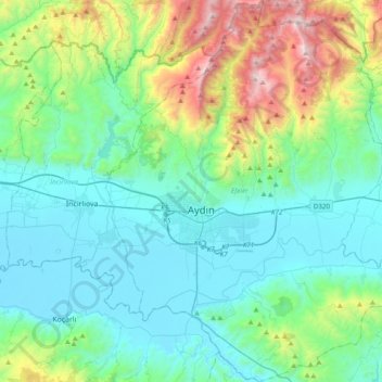
Name: Efeler topographic map, elevation, terrain.
Location: Efeler, Aydın, Ege Bölgesi, Turquía (37.70565 27.74718 37.99966 28.12373)
Average elevation: 354 m
Minimum elevation: 20 m
Maximum elevation: 1,690 m
Other topographic maps
Click on a map to view its topography, its elevation and its terrain.
Selçuk
Turquía > Ege Bölgesi > Selçuk
Selçuk, İzmir, Ege Bölgesi, 35920, Turquía
Average elevation: 127 m
Karaağaçlı
Turquía > Ege Bölgesi > Karaağaçlı
Karaağaçlı, Şehzadeler, Provincia de Manisa, Ege Bölgesi, 45040, Turquía
Average elevation: 30 m
Aydın
Turquía > Ege Bölgesi > Aydın
Aydın, Efeler, Aydın, Ege Bölgesi, 09020, Turquía
Average elevation: 348 m