
Lobuche topographic map
Interactive map
Click on the map to display elevation.
About this map
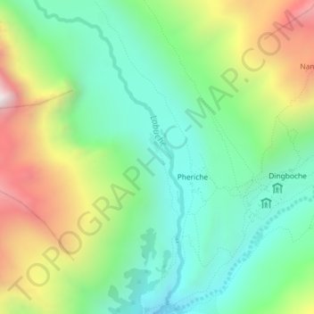
Name: Lobuche topographic map, elevation, terrain.
Average elevation: 4,825 m
Minimum elevation: 4,140 m
Maximum elevation: 6,447 m
Other topographic maps
Click on a map to view its topography, its elevation and its terrain.
Mount Everest
Nepal > Eastern Development Region > Tashi Dzom > Khumjung
Mount Everest, Khumjung, Solukhumbu, Sagarmatha, Eastern Development Region, Nepal
Average elevation: 7,841 m
Lhotse Shar
Nepal > Eastern Development Region > Khumjung
Lhotse Shar, Khumjung, Solukhumbu, Sagarmatha, Eastern Development Region, Nepal
Average elevation: 7,153 m