
Dunmore topographic map
Interactive map
Click on the map to display elevation.
About this map
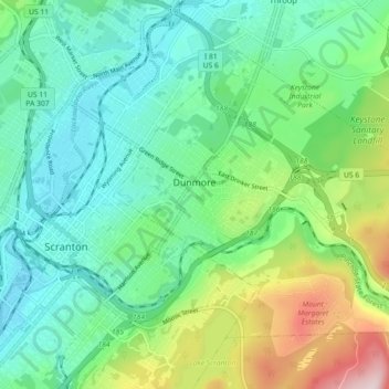
Name: Dunmore topographic map, elevation, terrain.
Average elevation: 312 m
Minimum elevation: 202 m
Maximum elevation: 606 m
Other topographic maps
Click on a map to view its topography, its elevation and its terrain.
Carbondale
United States > Pennsylvania > Lackawanna County
Carbondale, Lackawanna County, Pennsylvania, 18407, United States
Average elevation: 386 m