
Amherst topographic map
Interactive map
Click on the map to display elevation.
About this map
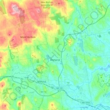
Name: Amherst topographic map, elevation, terrain.
Average elevation: 127 m
Minimum elevation: 50 m
Maximum elevation: 320 m
According to the United States Census Bureau, the town has a total area of 34.4 square miles (89.1 km2), of which 33.9 square miles (87.8 km2) are land and 0.50 square miles (1.3 km2), or 1.49% of the total area, are water. The entire town is part of the Merrimack River watershed. The Souhegan River, an east-flowing tributary of the Merrimack, passes through the southern part of the town, and the Souhegan's tributary Beaver Brook drains the central part of town and passes through the main village. Baboosic Lake is farther north, along the eastern border of the town and is fed by Joe English Brook. The lake drains to the east into Baboosic Brook, a tributary of the Merrimack. Pulpit Brook, which drains the northeast corner of the town, flows into Baboosic Brook as well. Witches Brook flows through the southernmost part of the town and is a tributary of Pennichuck Brook, yet another tributary of the Merrimack. Amherst's highest point is on Chestnut Hill at the town's northern border, where the elevation reaches 865 feet (264 m) above sea level.