
Tepoztlán topographic map
Interactive map
Click on the map to display elevation.
About this map
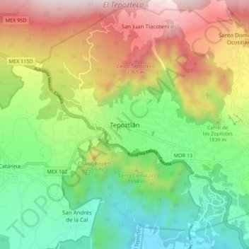
Name: Tepoztlán topographic map, elevation, terrain.
Location: Tepoztlán, Morelos, 62520, México (18.94615 -99.13980 19.02615 -99.05980)
Average elevation: 1,837 m
Minimum elevation: 1,333 m
Maximum elevation: 2,591 m
Other topographic maps
Click on a map to view its topography, its elevation and its terrain.
Santo Domingo Ocotitlán
Santo Domingo Ocotitlán, Tepoztlán, Morelos, 62523, México
Average elevation: 2,249 m
Santa Catarina
México > Morelos > Tepoztlán > Santa Catarina
Santa Catarina, Tepoztlán, Morelos, 62520, México
Average elevation: 1,646 m