
Gleisdorf topographic map
Interactive map
Click on the map to display elevation.
About this map
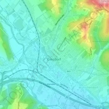
Name: Gleisdorf topographic map, elevation, terrain.
Location: Gleisdorf, Bezirk Weiz, Steiermark, 8200, Österreich (47.09180 15.69434 47.12155 15.72642)
Average elevation: 371 m
Minimum elevation: 338 m
Maximum elevation: 493 m
Mit dem Bau der Eisenbahn 1872 begann für den Markt Gleisdorf ein wirtschaftlicher Aufschwung, der seinen Höhepunkt mit der Errichtung eines Wasserkraftwerkes in der Stubenbergklamm erreichte. Auch das Rathaus wurde in dieser Zeit errichtet.
Other topographic maps
Click on a map to view its topography, its elevation and its terrain.
Ungerdorf
Österreich > Steiermark > Bezirk Weiz > Gleisdorf
Ungerdorf, Gleisdorf, Bezirk Weiz, Steiermark, 8200, Österreich
Average elevation: 405 m