
Getafe topographic map
Interactive map
Click on the map to display elevation.
About this map
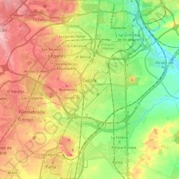
Name: Getafe topographic map, elevation, terrain.
Average elevation: 631 m
Minimum elevation: 549 m
Maximum elevation: 726 m
Getafe is located in the southern zone of the autonomous community of Madrid, Spain, in southwestern Europe. It is physically located in the centre of the Iberian Peninsula, north of the Southern Submeseta (part of the Meseta Central), in the Manzanares River basin. Its elevation is 610 – 640 meters above sea level (2000–2100 feet). Its coordinates are 40° 18' N 3° 43' W. The municipal district is 78.74 km2, with a perimeter of 46.5 km. The easternmost part of the municipal district is located within the Parque Regional del Sureste, a protected forest region.
Other topographic maps
Click on a map to view its topography, its elevation and its terrain.
Madrid
Spain > Community of Madrid > Área metropolitana de Madrid y Corredor del Henares > Madrid
Madrid, Área metropolitana de Madrid y Corredor del Henares, Community of Madrid, 28080, Spain
Average elevation: 650 m
Trafalgar
Spain > Community of Madrid > Área metropolitana de Madrid y Corredor del Henares > Madrid
Trafalgar, Chamberí, Madrid, Área metropolitana de Madrid y Corredor del Henares, Community of Madrid, 28001, Spain
Average elevation: 683 m