
Rajasthan topographic map
Interactive map
Click on the map to display elevation.
About this map
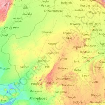
Name: Rajasthan topographic map, elevation, terrain.
Location: Rajasthan, India (23.05866 69.48444 30.19825 78.27201)
Average elevation: 254 m
Minimum elevation: -5 m
Maximum elevation: 2,299 m
The Aravalli Range runs across the state from the southwest peak Guru Shikhar (Mount Abu), which is 1,722 metres (5,650 ft) in height, to Khetri in the northeast. This range divides the state into 60% in the northwest of the range and 40% in the southeast. The northwest tract is sandy and unproductive with little water but improves gradually from desert land in the far west and northwest to comparatively fertile and habitable land towards the east. The area includes the Thar Desert. The south-eastern area, higher in elevation (100 to 350 m above sea level) and more fertile, has a very diversified topography. in the south lies the hilly tract of Mewar. In the southeast, a large area within the districts of Kota and Bundi forms a tableland. To the northeast of these districts is a rugged region (badlands) following the line of the Chambal River. Farther north the country levels out; the flat plains of the northeastern Bharatpur district are part of an alluvial basin. Merta City lies in the geographical centre of Rajasthan.
Other topographic maps
Click on a map to view its topography, its elevation and its terrain.
Mohali
India > Madhya Pradesh > Rehli Tahsil
Mohali, Rehli Tahsil, Sagar District, Madhya Pradesh, India
Average elevation: 430 m
Kashipur
India > Uttarakhand > Kashipur
Kashipur, Udham Singh Nagar District, Uttarakhand, 244713, India
Average elevation: 233 m
Dharamshala
India > Himachal Pradesh > Dharamshala
Dharamshala, Kangra District, Himachal Pradesh, 176200, India
Average elevation: 1,781 m
Dharav Parav
India > Madhya Pradesh > Bankhedi Tahsil
Dharav Parav, Bankhedi Tahsil, Narmadapuram District, Madhya Pradesh, India
Average elevation: 378 m
Bhagsu
India > Himachal Pradesh > Dharamshala
Bhagsu, Dharamshala, Kangra District, Himachal Pradesh, 176219, India
Average elevation: 1,955 m
Tholpetty
India > Kerala > Mananthavady
Tholpetty, Mananthavady, Wayanad District, Kerala, 571250, India
Average elevation: 875 m
Rampura
India > Gujarat > Detroj Rampura Taluka
Rampura, Detroj Rampura Taluka, Ahmedabad District, Gujarat, 382140, India
Average elevation: 42 m
Dantiwada dam
India > Gujarat > Dantiwada Taluka > Dantiwada
Dantiwada dam, Dantiwada, Dantiwada Taluka, Banaskantha District, Gujarat, 385505, India
Average elevation: 170 m
Gullah
India > Punjab > Guruharsahai Tahsil
Gullah, Guruharsahai Tahsil, Firozpur District, Punjab, 152024, India
Average elevation: 187 m
Machilipatnam
India > Andhra Pradesh > Machilipatnam
Machilipatnam, Krishna, Andhra Pradesh, 521001, India
Average elevation: 4 m
Thrikkunnapuzha
India > Kerala > Karthikappally
Thrikkunnapuzha, Karthikappally, Alappuzha District, Kerala, 690516, India
Average elevation: 2 m
Jaipur
India > Rajasthan > Jaipur Tehsil
Jaipur, Jaipur Municipal Corporation, Jaipur Tehsil, Jaipur, Rajasthan, 302001, India
Average elevation: 408 m
Maranda
India > Madhya Pradesh > Baihar Tahsil
Maranda, Baihar Tahsil, Balaghat District, Madhya Pradesh, India
Average elevation: 641 m
Waruda
India > Maharashtra > Teosa
Waruda, Teosa, Amravati, Maharashtra, India
Average elevation: 335 m
Mundi
India > Madhya Pradesh > Damoh Tahsil
Mundi, Damoh Tahsil, Damoh District, Madhya Pradesh, India
Average elevation: 364 m
Galore
Galore, Hamirpur District, Himachal Pradesh, 177006, India
Average elevation: 693 m
Suryapet
India > Telangana > Suryapet mandal
Suryapet, Suryapet mandal, Suryapet District, Telangana, 508213, India
Average elevation: 180 m
Vallapuzha
Vallapuzha, Pattambi, Palakkad District, Kerala, 679335, India
Average elevation: 56 m
Jaynagar - I
Jaynagar - I, South 24 Parganas District, West Bengal, India
Average elevation: 4 m
Bargara
India > Madhya Pradesh > Chitrangi Tahsil
Bargara, Chitrangi Tahsil, Singrauli District, Madhya Pradesh, India
Average elevation: 211 m
Kerla
India > Rajasthan > Pali Tehsil
Kerla, Pali Tehsil, Pali District, Rajasthan, India
Average elevation: 199 m
Rajkot
India > Gujarat > Rajkot East Taluka
Rajkot, Rajkot East Taluka, Rajkot District, Gujarat, 360001, India
Average elevation: 141 m
Bering
India > Punjab > Mukerian Tahsil
Bering, Mukerian Tahsil, Hoshiarpur District, Punjab, 144223, India
Average elevation: 622 m
Papan
India > Madhya Pradesh > Seoni-Malwa Tahsil
Papan, Seoni-Malwa Tahsil, Narmadapuram District, Madhya Pradesh, India
Average elevation: 281 m
Puducherry
India > Puducherry > Puducherry Taluk
Puducherry, Puducherry Taluk, Puducherry District, Puducherry, 605001, India
Average elevation: 10 m
Malak
India > Punjab > Kharar Tahsil
Malak, Kharar Tahsil, Sahibzada Ajit Singh Nagar District, Punjab, 140901, India
Average elevation: 352 m
Tharwa
India > Madhya Pradesh > Harrai Tahsil
Tharwa, Harrai Tahsil, Chhindwara District, Madhya Pradesh, India
Average elevation: 644 m
Sukma
India > Chhattisgarh > Sukma Tahsil
Sukma, Sukma Tahsil, Sukma District, Chhattisgarh, 494111, India
Average elevation: 219 m
Sullurpeta
India > Andhra Pradesh > Sullurpeta
Sullurpeta, Tirupati District, Andhra Pradesh, 524121, India
Average elevation: 4 m
Para River
India > Haryana > Siwan > KACHI PISOL
Para River, KACHI PISOL, Siwan, Kaithal District, Haryana, 136033, India
Average elevation: 235 m
Thiruvallur
Thiruvallur, Thiruvallur District, Tamil Nadu, India
Average elevation: 50 m
Western Sikkim Subsection
India > Sikkim > Chungthang
Western Sikkim Subsection, Chungthang, Mangan District, Sikkim, 737120, India
Average elevation: 3,896 m
Dei
India > Rajasthan > Nainwa Tehsil
Dei, Nainwa Tehsil, Bundi District, Rajasthan, India
Average elevation: 262 m