
Nebraska topographic map
Interactive map
Click on the map to display elevation.
About this map
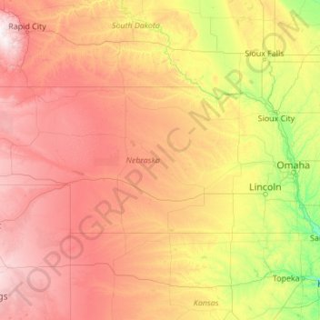
Name: Nebraska topographic map, elevation, terrain.
Location: Nebraska, United States (39.99998 -104.05352 43.00127 -95.30805)
Average elevation: 747 m
Minimum elevation: 255 m
Maximum elevation: 2,159 m
Nebraska is composed of two major land regions: the Dissected Till Plains and the Great Plains. The easternmost portion of the state was scoured by Ice Age glaciers; the Dissected Till Plains were left after the glaciers retreated. The Dissected Till Plains is a region of gently rolling hills; Omaha and Lincoln are in this region. The Great Plains occupy most of western Nebraska, with the region consisting of several smaller, diverse land regions, including the Sandhills, the Pine Ridge, the Rainwater Basin, the High Plains and the Wildcat Hills. Panorama Point, at 5,424 feet (1,653 m), is Nebraska's highest point; though despite its name and elevation, it is a relatively low rise near the Colorado and Wyoming borders. A past tourism slogan for the state of Nebraska was "Where the West Begins" (it has since been changed to "Honestly, it's not for everyone"). Locations given for the beginning of the "West" in Nebraska include the Missouri River, the intersection of 13th and O Streets in Lincoln (where it is marked by a red brick star), the 100th meridian, and Chimney Rock.
Other topographic maps
Click on a map to view its topography, its elevation and its terrain.
Roseville
United States > California > Placer County
Roseville, Placer County, California, United States
Average elevation: 61 m
Lynnwood
United States > Washington > Snohomish County
Lynnwood, Snohomish County, Washington, 98037, United States
Average elevation: 121 m
Largo
United States > Florida > Pinellas County
Largo, Pinellas County, Florida, United States
Average elevation: 9 m
Wake County
United States > North Carolina
Wake County, North Carolina, United States
Average elevation: 96 m
Ocean County
Ocean County, New Jersey, United States
Average elevation: 15 m
Redwood City
United States > California > San Mateo County
Redwood City, San Mateo County, California, United States
Average elevation: 32 m
Rudeston
United States > New York > Hamilton County
Rudeston, Town of Arietta, Hamilton County, New York, United States
Average elevation: 533 m
Fargo
United States > North Dakota > Cass County
Fargo, Cass County, North Dakota, United States
Average elevation: 277 m
Hennepin County
Hennepin County, Minnesota, United States
Average elevation: 280 m
San Antonio
United States > Texas > Bexar County
San Antonio, Bexar County, Texas, United States
Average elevation: 247 m
Puyallup
United States > Washington > Pierce County
Puyallup, Pierce County, Washington, United States
Average elevation: 66 m
Santa Ana Pueblo
United States > New Mexico > Sandoval County
Santa Ana Pueblo, Sandoval County, New Mexico, United States
Average elevation: 1,576 m
Hollis Park
United States > Arizona > Maricopa County > Tempe
Hollis Park, Tempe, Maricopa County, Arizona, United States
Average elevation: 362 m
Everett
United States > Washington > Snohomish County
Everett, Snohomish County, Washington, United States
Average elevation: 66 m
Moore County
United States > North Carolina
Moore County, North Carolina, United States
Average elevation: 127 m
Baltimore County
Baltimore County, Maryland, United States
Average elevation: 123 m
Beaverton
United States > Oregon > Washington County
Beaverton, Washington County, Oregon, United States
Average elevation: 106 m
Starks
United States > Maine > Somerset County
Starks, Somerset County, Maine, United States
Average elevation: 129 m
Good
United States > Virginia > Frederick County
Good, Frederick County, Virginia, 22625, United States
Average elevation: 356 m
Hickory
United States > North Carolina > Catawba County
Hickory, Catawba County, North Carolina, United States
Average elevation: 317 m
Litchfield County
United States > Connecticut > Northwest Hills Planning Region
Litchfield County, Northwest Hills Planning Region, Connecticut, United States
Average elevation: 252 m
Little Egg Harbor
United States > New Jersey > Ocean County > Little Egg Harbor Township
Little Egg Harbor, Little Egg Harbor Township, Ocean County, New Jersey, United States
Average elevation: 2 m
Park Ridge
United States > Illinois > Cook County
Park Ridge, Maine Township, Cook County, Illinois, 60068, United States
Average elevation: 198 m
Crescent City
United States > California > Del Norte County
Crescent City, Del Norte County, California, United States
Average elevation: 31 m
Evergreen
United States > Colorado > Jefferson County
Evergreen, Jefferson County, Colorado, 80457, United States
Average elevation: 2,301 m
Whidbey Island
United States > Washington > Island County
Whidbey Island, Island County, Washington, United States
Average elevation: 45 m
Bennet Park
United States > Michigan > Eaton County > Charlotte
Bennet Park, Charlotte, Eaton Township, Eaton County, Michigan, United States
Average elevation: 277 m
Easton
United States > Massachusetts > Bristol County
Easton, Bristol County, Massachusetts, United States
Average elevation: 47 m
Newtown
United States > Connecticut > Western Connecticut Planning Region
Newtown, Western Connecticut Planning Region, Connecticut, United States
Average elevation: 147 m
Lake Of The Ozarks
United States > Missouri > Camden County > Osage Beach
Lake Of The Ozarks, Osage Beach, Camden County, Missouri, 65079, United States
Average elevation: 265 m
Tampa
United States > Florida > Hillsborough County
Tampa, Hillsborough County, Florida, United States
Average elevation: 11 m
Freeburn
United States > Kentucky > Pike County
Freeburn, Pike County, Kentucky, 41528, United States
Average elevation: 342 m
Mount Ida
United States > Arkansas > Montgomery County
Mount Ida, Montgomery County, Arkansas, United States
Average elevation: 215 m
Gloucester
United States > Massachusetts > Essex County > Gloucester
Gloucester, Essex County, Massachusetts, 01930, United States
Average elevation: 15 m
Highlands
United States > North Carolina > Macon County
Highlands, Macon County, North Carolina, 28741, United States
Average elevation: 1,116 m
Town of Perry
United States > New York > Wyoming County
Town of Perry, Wyoming County, New York, 14530, United States
Average elevation: 403 m
Little Blue Lake
United States > Washington > Skamania County
Little Blue Lake, Skamania County, Washington, United States
Average elevation: 158 m
Cloud Forest
United States > Florida > Miami-Dade County
Cloud Forest, Miami-Dade County, Florida, 33177, United States
Average elevation: 6 m
Quilcene
United States > Washington > Jefferson County > Quilcene
Quilcene, Jefferson County, Washington, United States
Average elevation: 268 m
Brandon
United States > Mississippi > Rankin County
Brandon, Rankin County, Mississippi, 39042, United States
Average elevation: 118 m
Shooks Gap
United States > Tennessee > Sevier County
Shooks Gap, Seymour, Sevier County, East Tennessee, Tennessee, 37865, United States
Average elevation: 327 m
South Cove Park
United States > Washington > King County > Issaquah
South Cove Park, Issaquah, King County, Washington, United States
Average elevation: 40 m
City of Ogdensburg
United States > New York > Saint Lawrence County
City of Ogdensburg, Saint Lawrence County, New York, United States
Average elevation: 85 m
Pushmataha County
Pushmataha County, Oklahoma, United States
Average elevation: 240 m
Errol
United States > New Hampshire > Coos County
Errol, Coös County, New Hampshire, United States
Average elevation: 453 m
Sibley County
Sibley County, Minnesota, United States
Average elevation: 304 m