
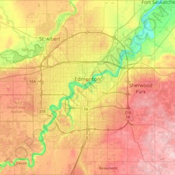
Edmonton topographic map
Interactive map
Click on the map to display elevation.
About this map
Name: Edmonton topographic map, elevation, terrain.
Location: Edmonton, Alberta, Canada (53.33726 -113.71384 53.71626 -113.27148)
Average elevation: 690 m
Minimum elevation: 600 m
Maximum elevation: 783 m
Edmonton is on the North Saskatchewan River, at an elevation of 671 m (2,201 ft). It is North America's northernmost city with a metropolitan population over one million. It is at the same latitude as Hamburg (Germany); Dublin (Ireland); Manchester (United Kingdom); and Magnitogorsk (Russia). It is south of Alberta's geographic centre, which is near the Hamlet of Fort Assiniboine. The terrain in and around Edmonton is generally flat to gently rolling, with ravines and deep river valleys, such as the North Saskatchewan River valley. The Canadian Rockies are west of Edmonton and about 220 km (140 mi) to the southwest.
Other topographic maps
Click on a map to view its topography, its elevation and its terrain.
Southwood
Canada > Alberta > Division No. 11
Southwood, Mill Woods, Division No. 11, Alberta, Canada
Average elevation: 710 m
Woodcroft
Canada > Alberta > Division No. 11
Woodcroft, Western Mature Area, Division No. 11, Alberta, Canada
Average elevation: 673 m
City of Spruce Grove
Canada > Alberta > Division No. 11
City of Spruce Grove, Division No. 11, Alberta, Canada
Average elevation: 699 m
King Edward Park
Canada > Alberta > Division No. 11 > Edmonton
King Edward Park, Mill Creek South, Edmonton, Division No. 11, Alberta, Canada
Average elevation: 671 m
Callaghan
Canada > Alberta > Division No. 11
Callaghan, Heritage Valley, Division No. 11, Alberta, T6W 0R7, Canada
Average elevation: 694 m