
Sofia topographic map
Interactive map
Click on the map to display elevation.
About this map
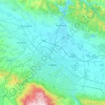
Name: Sofia topographic map, elevation, terrain.
Location: Sofia, Sofia City, Sofia-City, Bulgaria (42.60309 23.19509 42.78679 23.43248)
Average elevation: 644 m
Minimum elevation: 505 m
Maximum elevation: 1,890 m
Other topographic maps
Click on a map to view its topography, its elevation and its terrain.
m. Smagovo
Bulgaria > Sofia-City > Novi Iskar
m. Smagovo, kv. Kurilo, Novi Iskar, Sofia City, Sofia-City, 1280, Bulgaria
Average elevation: 520 m