
Bogor topographic map
Interactive map
Click on the map to display elevation.
About this map
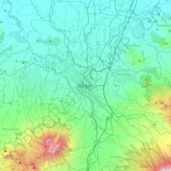
Name: Bogor topographic map, elevation, terrain.
Location: Bogor, West Java, 16121, Indonesia (-6.75630 106.63724 -6.43630 106.95724)
Average elevation: 442 m
Minimum elevation: 47 m
Maximum elevation: 2,397 m
The city is situated in the western part of Java island, about 53 km south of the capital Jakarta and 85 km northwest of Bandung, the administrative center of West Java Province. Bogor spreads over a basin near volcanoes Salak, which peaks at about 12 km south, and Mount Gede whose top is 22–25 km south-east of the city. The average elevation is 265 meters, maximum 330 m, and minimum 190 meters above sea level. The terrain is rather uneven: 17.64 km² of its area has slopes of 0–2°, 80.9 km² from 2° to 15°, 11 km² between 15° and 25°, 7.65 km² from 25° to 40° and 1.20 km² over 40°; the northern part is relatively flat and the southern part is more hilly.
Other topographic maps
Click on a map to view its topography, its elevation and its terrain.