
Cairo topographic map
Interactive map
Click on the map to display elevation.
About this map
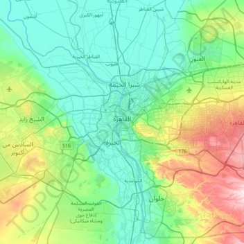
Name: Cairo topographic map, elevation, terrain.
Location: Cairo, Egypt (29.74831 31.22003 30.32092 31.90901)
Average elevation: 112 m
Minimum elevation: 2 m
Maximum elevation: 522 m
Other topographic maps
Click on a map to view its topography, its elevation and its terrain.
Districts of El Tagamoa El Khames
Egypt > Cairo > New Cairo City
Districts of El Tagamoa El Khames, New Cairo City, Cairo, 11936, Egypt
Average elevation: 278 m
Industrial District
Egypt > Cairo > New Cairo City
Industrial District, New Cairo City, Cairo, 11835, Egypt
Average elevation: 350 m