
Fairy Falls topographic map
Interactive map
Click on the map to display elevation.
About this map
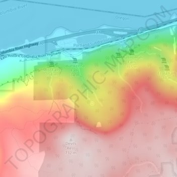
Name: Fairy Falls topographic map, elevation, terrain.
Average elevation: 376 m
Minimum elevation: 0 m
Maximum elevation: 742 m
Other topographic maps
Click on a map to view its topography, its elevation and its terrain.
Gresham
United States > Oregon > Multnomah County
Gresham, Multnomah County, Oregon, United States
Average elevation: 90 m
Portland
United States > Oregon > Multnomah County
Portland, Multnomah County, Oregon, United States
Average elevation: 77 m