
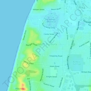
South Bunbury topographic map
Interactive map
Click on the map to display elevation.
About this map
Name: South Bunbury topographic map, elevation, terrain.
Average elevation: 9 m
Minimum elevation: 0 m
Maximum elevation: 57 m
Other topographic maps
Click on a map to view its topography, its elevation and its terrain.
Uduc
Australia > Western Australia > Bunbury
Uduc, Bunbury, Western Australia, 6220, Australia
Average elevation: 22 m
Wellington National Park
Australia > Western Australia > Bunbury
Wellington National Park, Lennard Drive, Bunbury, Western Australia, 6226, Australia
Average elevation: 217 m
Mungalup
Australia > Western Australia > Bunbury > Mungalup
Mungalup, Bunbury, Western Australia, Australia
Average elevation: 266 m