
Palm Springs topographic map
Interactive map
Click on the map to display elevation.
About this map
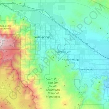
Name: Palm Springs topographic map, elevation, terrain.
Location: Palm Springs, Riverside County, California, United States (33.61242 -116.68448 33.93198 -116.44281)
Average elevation: 698 m
Minimum elevation: 11 m
Maximum elevation: 3,274 m
One possible origin of palm in the place name comes from early Spanish explorers who referred to the area as La Palma de la Mano de Dios or "The Palm of God's hand".[27] The earliest use of the name "Palm Springs" is from United States Topographical Engineers who used the term in 1853 maps.[28] According to William Bright, when the word "palm" appears in Californian place names, it usually refers to the native California fan palm, Washingtonia filifera, which is abundant in the Palm Springs area.[29] Other early names were "Palmetto Spring" and "Big Palm Springs".[30]
Other topographic maps
Click on a map to view its topography, its elevation and its terrain.
Joshua Tree National Park
United States > California > Riverside County
Joshua Tree National Park, Riverside County, California, United States
Average elevation: 639 m
Moreno Valley
United States > California > Riverside County
Moreno Valley, Riverside County, California, United States
Average elevation: 527 m
Indio
United States > California > Riverside County
Indio, Riverside County, California, United States
Average elevation: 74 m
Canyon Lake
United States > California > Riverside County > Canyon Lake
Canyon Lake, Riverside County, California, United States
Average elevation: 461 m
Indian Wells
United States > California > Riverside County > Indian Wells
Indian Wells, Riverside County, California, 92210, United States
Average elevation: 118 m
Corona
United States > California > Riverside County
Corona, Riverside County, CAL Fire Southern Region, California, United States
Average elevation: 377 m
Lake Elsinore
United States > California > Riverside County > Lake Elsinore > Lake Elsinore
Lake Elsinore, Riverside County, California, 92532, United States
Average elevation: 428 m
Coachella
United States > California > Riverside County > Coachella
Coachella, Riverside County, California, 92236, United States
Average elevation: 22 m
Mesa Verde
United States > California > Riverside County > Mesa Verde
Mesa Verde, Riverside County, California, United States
Average elevation: 120 m
Riverside
United States > California > Riverside County > Riverside
Riverside, Riverside County, California, United States
Average elevation: 351 m